Four things we’d need to put data centers in space

MIT Technology Review Explains: Let our writers untangle the complex, messy world of technology to help you understand what’s coming next. You can read more from the series here.

In January, Elon Musk’s SpaceX filed an application with the US Federal Communications Commission to launch up to one million data centers into Earth’s orbit. The goal? To fully unleash the potential of AI without triggering an environmental crisis on Earth. But could it work?

SpaceX is the latest in a string of high-tech companies extolling the potential of orbital computing infrastructure. Last year, Amazon founder Jeff Bezos said that the tech industry will move toward large-scale computing in space. Google has plans to loft data-crunching satellites, aiming to launch a test constellation of 80 as early as next year. And last November Starcloud, a startup based in Washington State, launched a satellite fitted with a high-performance Nvidia H100 GPU, marking the first orbital test of an advanced AI chip. The company envisions orbiting data centers as large as those on Earth by 2030.

Proponents believe that putting data centers in space makes sense. The current AI boom is straining energy grids and adding to the demand for water, which is needed to cool the computers. Communities in the vicinity of large-scale data centers worry about increasing prices for those resources as a result of the growing demand, among other issues.

In space, advocates say, the water and energy problems would be solved. In constantly illuminated sun-synchronous orbits, space-borne data centers would have uninterrupted access to solar power. At the same time, the excess heat they produce would be easily expelled into the cold vacuum of space. And with the cost of space launches decreasing, and mega-rockets such as SpaceX’s Starship promising to push prices even lower, there could be a point at which moving the world’s data centers into space makes sound business sense. Detractors, on the other hand, tell a different story and point to a variety of technological hurdles, though some say it’s possible they may be surmountable in the not-so-distant future. Here are four of the must-haves we’d need to make space-based data centers a reality. 

A way to carry away heat 

AI data centers produce a lot of heat. Space might seem like a great place to dispel that heat without using up massive amounts of water. But it’s not so simple. To get the power needed to run 24-7, a space-based data center would have to be in a constantly illuminated orbit, circling the planet from pole to pole, and never hide in Earth’s shadow. And in that orbit, the temperature of the equipment would never drop below 80 °C, which is way too hot for electronics to operate safely in the long term. 

Getting the heat out of such a system is surprisingly challenging. “Thermal management and cooling in space is generally a huge problem,” says Lilly Eichinger, CEO of the Austrian space tech startup Satellives.

On Earth, heat dissipates mostly through the natural process of convection, which relies on the movement of gases and liquids like air and water. In the vacuum of space, heat has to be removed through the far less efficient process of radiation. Safely removing the heat produced by the computers, as well as what’s absorbed from the sun, requires large radiative surfaces. The bulkier the satellite, the harder it is to send all the heat inside it out into space.

But Yves Durand, former director of technology at the European aerospace giant Thales Alenia Space, says that technology already exists to tackle the problem.

The company previously developed a system for large telecommunications satellites that can pipe refrigerant fluid through a network of tubing using a mechanical pump, ultimately transferring heat from within a spacecraft to radiators on the exterior. Durand led a 2024 feasibility study on space-based data centers, which found that although challenges exist, it should be possible for Europe to put gigawatt-scale data centers (on par with the largest Earthbound facilities) into orbit before 2050. These would be considerably larger than those envisioned by SpaceX, featuring solar arrays hundreds of meters in size—larger than the International Space Station.

Computer chips that can withstand a radiation onslaught

The space around Earth is constantly battered by cosmic particles and lashed by solar radiation. On Earth’s surface, humans and their electronic devices are protected from this corrosive soup of charged particles by the planet’s atmosphere and magnetosphere. But the farther away from Earth you venture, the weaker that protection becomes. Studies show that aircraft crews have a higher risk of developing cancer because of their frequent exposure to high radiation at cruising altitude, where the atmosphere is thin and less protective.

Electronics in space are at risk of three types of problems caused by high radiation levels, says Ken Mai, a principal systems scientist in electrical and computer engineering at Carnegie Mellon University. Phenomena known as single-event upsets can cause bit flips and corrupt stored data when charged particles hit chips and memory devices. Over time, electronics in space accumulate damage from ionizing radiation that degrades their performance. And sometimes a charged particle can strike the component in a way that physically displaces atoms on the chip, creating permanent damage, Mai explains.

Traditionally, computers launched to space had to undergo years of testing and were specifically designed to withstand the intense radiation present in Earth’s orbit. These space-hardened electronics are much more expensive, though, and their performance is also years behind the state-of-the-art devices for Earth-based computing. Launching conventional chips is a gamble. But Durand says cutting-edge computer chips use technologies that are by default more resistant to radiation than past systems. And in mid-March, Nvidia touted hardware, including a new GPU, that is “bringing AI compute to orbital data centers.” 

Nvidia’s head of edge AI marketing, Chen Su, told MIT Technology Review, that “Nvidia systems are inherently commercial off the shelf, with radiation resilience achieved at the system level rather than through radiation‑hardened silicon alone.” He added that satellite makers increase the chips’ resiliency with the help of shielding, advanced software for error detection, and architectures that combine the consumer-grade devices with bespoke, hardened technologies.

Still, Mai says that the data-crunching chips are only one issue. The data centers would also need memory and storage devices, both of which are vulnerable to damage by excessive radiation. And operators would need the ability to swap things out or adapt when issues arise. The feasibility and affordability of using robots or astronaut missions for maintenance is a major question mark hanging over the idea of large-scale orbiting data centers.

“You not only need to throw up a data center to space that meets your current needs; you need redundancy, extra parts, and reconfigurability, so when stuff breaks, you can just change your configuration and continue working,” says Mai. “It’s a very challenging problem because on one hand you have free energy and power in space, but there are a lot of disadvantages. It’s quite possible that those problems will outweigh the advantages that you get from putting a data center into space.”

In addition to the need for regular maintenance, there’s also the potential for catastrophic loss. During periods of intense space weather, satellites can be flooded with enough radiation to kill all their electronics. The sun has just passed the most active phase of its 11-year cycle with relatively little impact on satellites. Still, experts warn that since the space age began, the planet has not experienced the worst the sun is capable of. Many doubt whether the low-cost new space systems that dominate Earth’s orbits today are prepared for that.

A plan to dodge space debris

Both large-scale orbiting data centers such as those envisioned by Thales Alenia Space and the mega-constellations of smaller satellites as proposed by SpaceX give a headache to space sustainability experts. The space around Earth is already quite crowded with satellites. Starlink satellites alone perform hundreds of thousands of collision avoidance maneuvers every year to dodge debris and other spacecraft. The more stuff in space, the higher the likelihood of a devastating collision that would clutter the orbit with thousands of dangerous fragments.

Large structures with hundreds of square meters of solar arrays would quickly suffer damage from small pieces of space debris and meteorites, which would over time degrade the performance of their solar panels and create more debris in orbit. Operating one million satellites in low Earth orbit, the region of space at the altitude of up to 2,000 kilometers, might be impossible to do safely unless all satellites in that area are part of the same network so they can communicate effectively to maneuver around each other, Greg Vialle, the founder of the orbital recycling startup Lunexus Space, told MIT Technology Review.

“You can fit roughly four to five thousand satellites in one orbital shell,” Vialle says. “If you count all the shells in low Earth orbit, you get to a number of around 240,000 satellites maximum.”

And spacecraft must be able to pass each other at a safe distance to avoid collisions, he says. 

“You also need to be able to get stuff up to higher orbits and back down to de-orbit,” he adds. “So you need to have gaps of at least 10 kilometers between the satellites to do that safely. Mega-constellations like Starlink can be packed more tightly because the satellites communicate with each other. But you can’t have one million satellites around Earth unless it’s a monopoly.”

On top of that, Starlink would likely want to regularly upgrade its orbiting data centers with more modern technology. Replacing a million satellites perhaps every five years would mean even more orbital traffic—and it could increase the rate of debris reentry into Earth’s atmosphere from around three or four pieces of junk a day to about one every three minutes, according to a group of astronomers who filed objections against SpaceX’s FCC application. Some scientists are concerned that reentering debris could damage the ozone layer and alter Earth’s thermal balance

Economical launch and assembly

The longer hardware survives in orbit, the better the return on investment. But for orbital data centers to make economic sense, companies will have to find a relatively cheap way to get that hardware in orbit. SpaceX is betting on its upcoming Starship mega-rocket, which will be able to carry up to six times as much payload as the current workhorse, Falcon 9. The Thales Alenia Space study concluded that if Europe were to build its own orbital data centers, it would have to develop a similarly potent launcher. 

But launch is only part of the equation. A large-scale orbital data center won’t fit in a rocket—even a mega-rocket. It will need to be assembled in orbit. And that will likely require advanced robotic systems that do not exist yet. Various companies have conducted Earth-based tests with precursors of such systems, but they are still far from real-world use.

Durand says that in the short term, smaller-scale data centers are likely to establish themselves as an integral part of the orbital infrastructure, by processing images from Earth-observing satellites directly in space without having to send them to Earth. That would be a huge help for companies selling insights from space, as many of these data sets are extremely large, and competition for opportunities to downlink them to Earth for processing via ground stations is growing.

“The good thing with orbital data centers is that you can start with small servers and gradually increase and build up larger data centers,” says Durand. “You can use modularity. You can learn little by little and gradually develop industrial capacity in space. We have all the technology, and the demand for space-based data processing infrastructure is huge, so it makes sense to think about it.”

Smaller facilities probably won’t do much to offset the strain that terrestrial data centers are placing on the planet’s water and electricity, though. That vision of the future might take decades to come to fruition, some critics think—if it even gets off the ground at all. 

Roundtables: The Next Era of Space Exploration

Listen to the session or watch below

Whether it’s the race to find life on Mars, the campaign to outsmart killer asteroids, or the quest to make the moon a permanent home to astronauts, scientists’ efforts in space can tell us more about where humanity is headed. This subscriber-only discussion examines the progress and possibilities ahead.

Speakers: Amanda Silverman, features & investigations editor, and Robin George Andrews, award-winning science journalist and author

Recorded on March 25, 2026

Related Stories:

America was winning the race to find Martian life. Then China jumped in.

To most people, rocks are just rocks. To geologists, they are much, much more: crystal-filled time capsules with the power to reveal the state of the planet at the very moment they were forged. 

For decades, NASA had been on a time capsule hunt like none other—one across Mars.

Its rovers have journeyed around a nightmarish ocher desert that, billions of years ago, was home to rivers, lakes, perhaps even seas and oceans. They’ve been seeking to answer a momentous question: Once upon a time, did microbial life wriggle across its surface? 

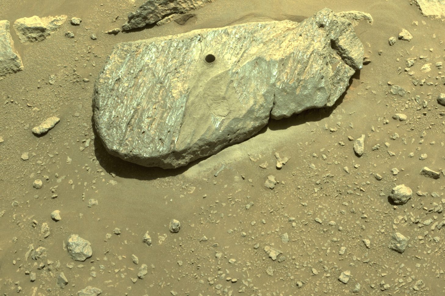
Then, in July 2024, after more than three years on the planet, the Perseverance rover came across a peculiar rocky outcrop. Instead of the usual crystals or layers of sediment, this one had spots. Two kinds, in fact: one that looked like poppy seeds, and another that resembled those on a leopard. It’s possible that run-of-the-mill chemical reactions could have cooked up these odd features. But on Earth, these marks are almost always produced by microbial life.

To put it plainly: Holy crap.

Sure, those specks are not definitive proof of alien life. But they are the best hint yet that life may not be a one-off event in the cosmos. And they meant the most existential question of all—Are we alone?—might soon be addressed. “If you do it, then human history is never the same,” says Casey Dreier, chief of space policy at the Planetary Society, a nonprofit that promotes planetary exploration and defense and the search for extraterrestrial life.

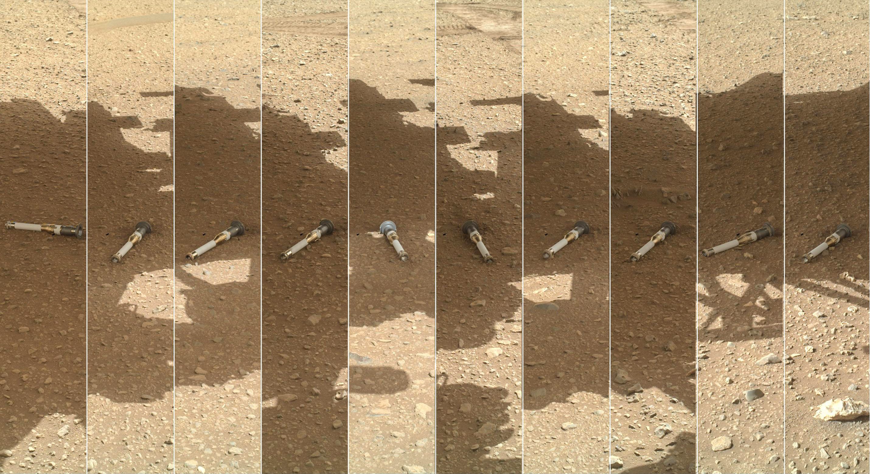
But the only way to confirm whether these seeds and spots are the fossilized imprint of alien biology is to bring a sample of that rock home to study. 

Perseverance was the first stage of an ambitious scheme to do just that—in effect, to pull off a space heist. The mission—called Mars Sample Return and planned by the US, along with its European partners—would send a Rube Goldberg–like series of robotic missions to the planet to capture pristine rocks. The rover’s job was to find the most promising stones and extract samples; then it would pass them to another robot—the getaway driver—to take them off Mars and deliver them to Earth.

But now, just over a year and a half later, the project is on life support, with zero funding flowing in 2026 and little backing left in Congress. As a result, those oh-so-promising rocks may be stuck out there forever.

“We’ve spent 50 years preparing to get these samples back. We’re ready to do that,” says Philip Christensen, a planetary scientist at Arizona State University who works closely with NASA. “Now we’re two feet from the finish line—Oh, sorry, we’re not going to complete the job.”

This also means that, in the race to find evidence of alien life, America has effectively ceded its pole position to its greatest geopolitical rival: China. The superpower is moving full steam ahead with its own version of MSR. It’s leaner than America and Europe’s mission, and the rock samples it will snatch from Mars will likely not be as high quality. But that won’t be the headline people remember—the one in the scientific journals and the history books. “At the rate we’re going, there’s a very good chance they’ll do it before we do,” laments Christensen. “Being there first is what matters.”  

Of course, any finding of extraterrestrial life advances human knowledge writ large, no matter the identity of the discoverers. But there is the not-so-small issue of pride in an already heated nationalistic competition, not to mention the fact that many scientists in America (to say nothing of US lawmakers) don’t necessarily want their future research and scientific progress subject to a foreign gatekeeper. And even for those not especially concerned about potentially unearthing alien microbes, MSR and the comparable Chinese mission are technological stepping stones toward a long-held dream shared by many beyond Elon Musk: getting astronauts onto the Red Planet and, eventually, setting up long-term bases for astronauts there. It’d be a huge blow to show up only after a competitor had already set up shop … or not to get there at all. 

“If we can’t do this, how do we think we’re gonna send humans there and get back safely?” says Victoria Hamilton, a planetary geologist at the Southwest Research Institute in Boulder, Colorado, who is also the chair of the NASA-affiliated Mars Exploration Program Analysis Group. 

Or as Paul Byrne, a planetary scientist from the Washington University in St. Louis, puts it: “If you’re going to bring humans back from Mars, you sure as shit have to figure out how to bring the samples back first.” 

Nearly a dozen project insiders and scientists in both the US and China shared with me the story of how America blew its lead in the new space race. It’s full of wild dreams and promising discoveries—as well as mismanagement, eye-watering costs, and, ultimately, anger and disappointment.    


“I spent most of my career studying Mars,” says Christensen. There are countless things about it that bewitch him. But by examining it, he suspects, we’ll get further than ever in the Homeric investigation of how life began.

Sure, the Mars of today is a postapocalyptic wasteland, an arid and cold desert bathed in lethal radiation. But billions of years ago, water lapped up against the slopes of fiery volcanoes that erupted under a clement sky. Then its geologic interior cooled down so quickly, changing everything. Its global magnetic field collapsed like a deflating balloon, and its protective atmosphere was stripped away by the sun. 

NASA first touched down on Mars in 1976 with two Viking landers. The Mars Odyssey spacecraft has been orbiting the planet since 2001 and produced this image of Valles Marineris, which is 10 times longer, 5 times deeper, and 20 times wider than the Grand Canyon.
NASA/ARIZONA STATE UNIVERSITY VIA GETTY IMAGES

Its surface is now remarkably hostile to life as we know it. But deep below ground, where it’s shielded from space, and where it’s warmer and wetter, there could maybe be microbes inching about.

Scientists have long possessed several Martian meteorites that have been flung our way, but none of them are pristine; they were all damaged by cosmic radiation midflight, before getting scorched in Earth’s atmosphere. Plus, there’s another problem: “We currently have no rocks from Mars that are sedimentary, the rock type likely to contain fossils,” says Sara Russell, a planetary scientist at London’s Natural History Museum. 

For those, humans (or robots) would need to get on the ground.

NASA first made the stuff of sci-fi films a reality 50 years ago, when two Viking landers touched down on the planet in 1976. One of their experiments dropped some radioactively tagged nutrients into soil samples, the idea being that if any microbes were present, they’d gobble up the nutrients and burp out some radioactive waste gas that the landers could detect. Tantalizingly, this experiment hinted that something microbe-like was interacting with those nutrients—but the result was inconclusive (and today most scientists don’t suspect biology was responsible).

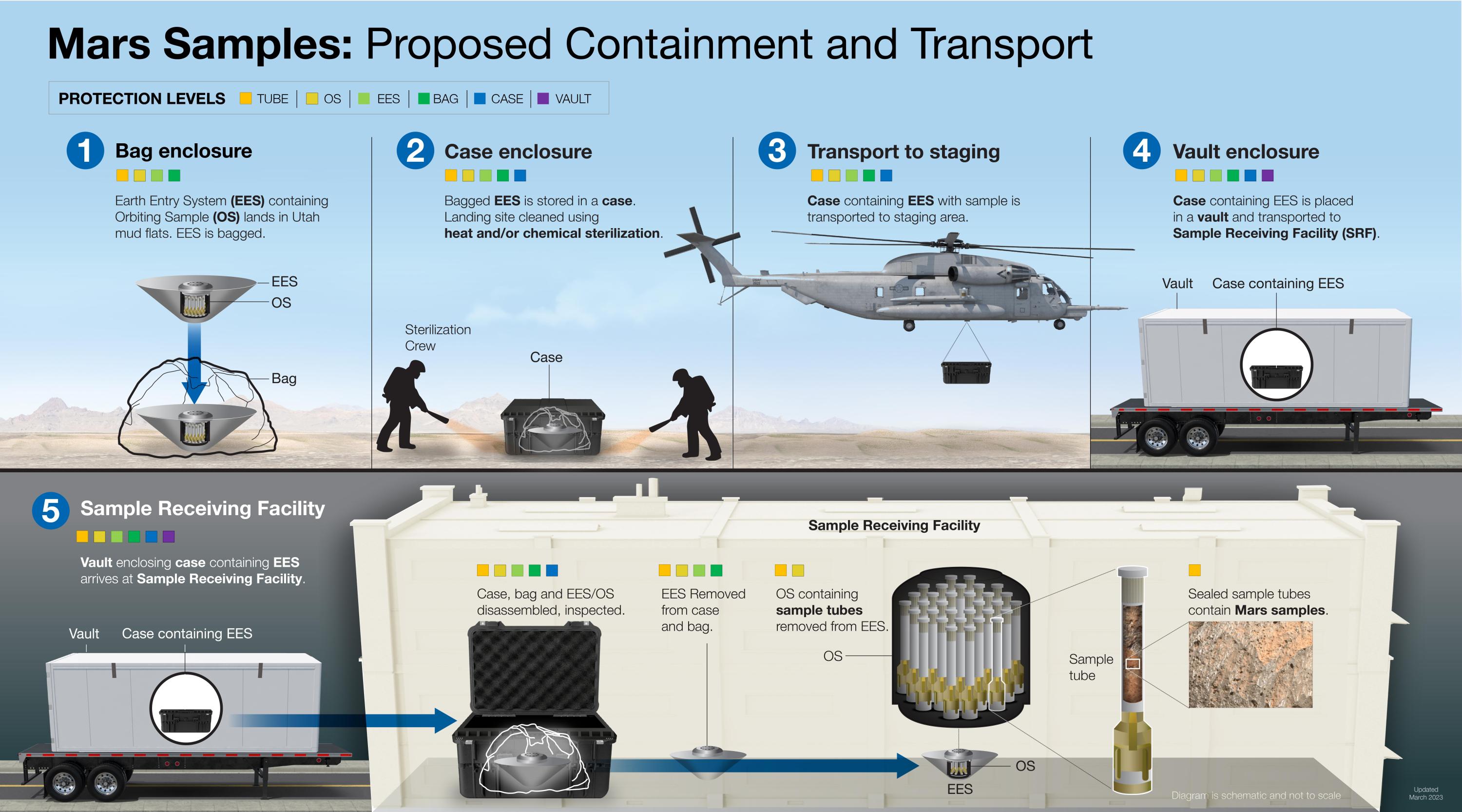
Still, it was enough to elevate scientists’ curiosity about the genuine possibility of Martian life. Over the coming decades, America sent an ever-expanding fleet of robots to Mars—orbiting spacecraft, landers, and wheeled rovers. But no matter how hard they studied their adoptive planet’s rocks, they weren’t designed to definitively detect signs of life. For that, promising-looking rocks would need to be captured and, somehow, shuttled back to labs on Earth in carefully sealed containers. 

A 2023 plan from NASA and the European Space Agency to safely transport pristine samples received from Mars.
NASA/JPL-CALTECH

This became a top priority for the US planetary science community in 2003, following the publication of the first Planetary Decadal Survey, a census conducted at NASA’s request. The scientific case for the mission was clear—even to the people who didn’t think they’d find signs of life. “I bet there isn’t life on Mars. But if there is, or was, that would be an incredibly important discovery,” says Christensen. And if not, “Why not?” 

He adds: “We may understand more about why life started on Earth by understanding why it may not have started on Mars. What was that key difference between those two planets?”

And so, MSR was born. America went all in, and the European Space Agency joined the team. Over the next decade or so, a complex plan was drawn up. 

First, a NASA rover would land on Mars in a spot that once was potentially habitable—later determined to be Jezero Crater. It would zip about, look for layered rocks of the sort that you’d find in lakes and riverbeds, extract cores of them, and cache them in sealed containers. Then a second NASA spacecraft would land on Mars, receive the rover’s sample tubes (in one of several different ways), and transfer the samples to a rocket that would launch them into Martian orbit. A European-provided orbiter would catch that rocket like a baseball glove before returning home and dropping the rocks into Earth’s atmosphere, where they would be guided, via parachute, to eagerly awaiting scientists no later than the mid-2030s.

Two messages were encoded on the 70-foot parachute used by the Perseverance rover as it descended toward Mars. This annotated image shows how NASA systems engineer Ian Clark used a binary code to spell out “Dare Mighty Things” in the orange and white strips; he also included the GPS coordinates for the mission’s headquarters at the Jet Propulsion Laboratory.
NASA/JPL-CALTECH VIA AP IMAGES

“Put simply, this is the most scientifically careful sample collection mission possible, conducted in one of the most promising places on Mars to look for signs of past life,” says Jonathan Lunine, the chief scientist at NASA’s Jet Propulsion Laboratory in California. “And, of course, should evidence of life be found in the sediments, that would be an historic discovery.”

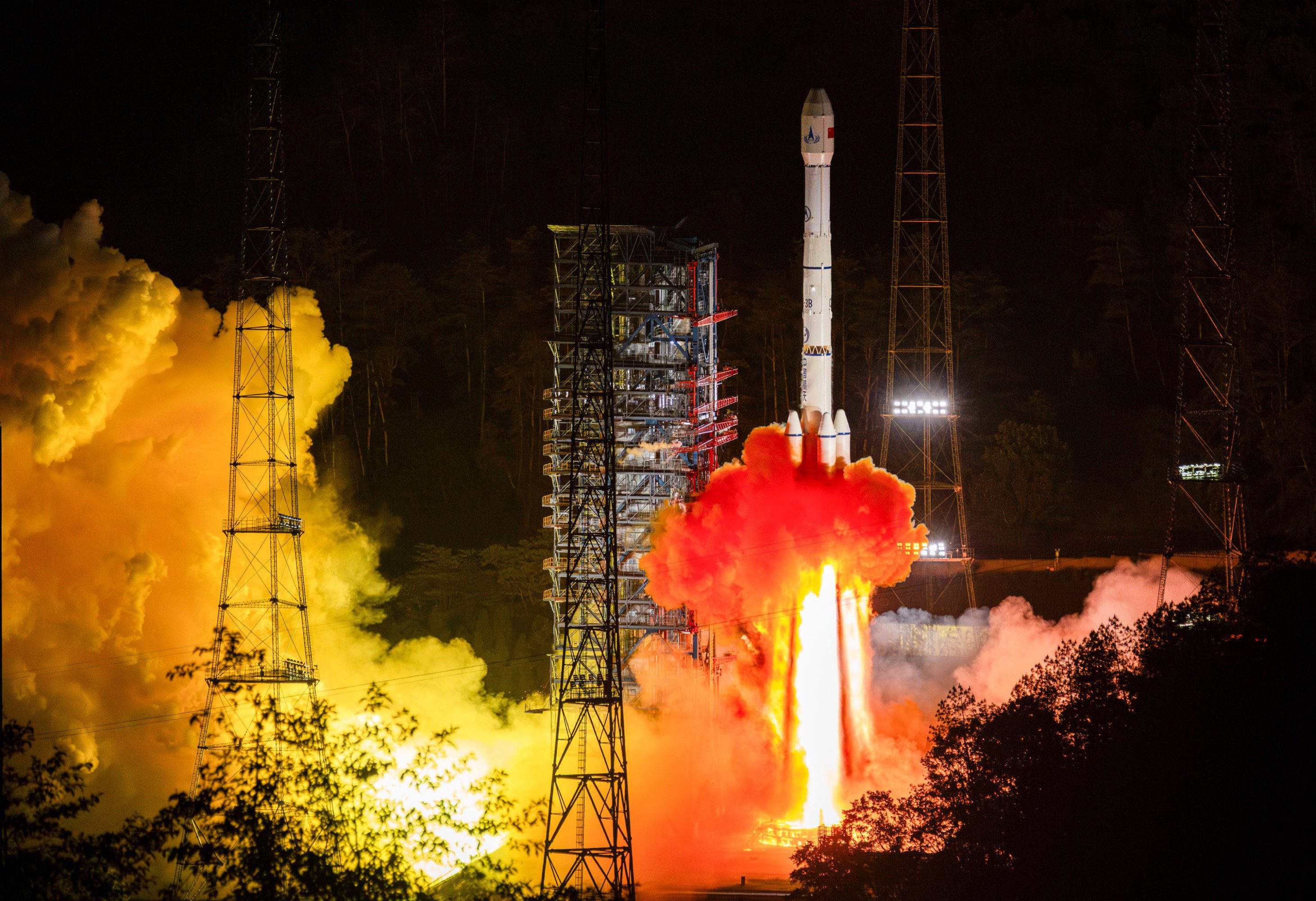
It got off to an auspicious start. On July 30, 2020, in the throes of the covid-19 pandemic, NASA’s Perseverance rover launched atop a rocket from Florida’s Cape Canaveral. The NASA administrator at the time, Jim Bridenstine, didn’t mince words: “We are in extraordinary times right now,” he told reporters, “yet we have in fact persevered, and we have protected this mission because it is so important.” 

But just earlier that same month, the mission to Mars had turned into a race. China was now prepping its own sample return spacecraft.

And that’s when things for MSR started to unravel. 

XINMEI LIU

China was comparatively late to develop a competitive space program, but once it began doing so, it wasted no time. In 2003, it first sent one of its astronauts into space, via its own bespoke rocket; in the two decades since, it has launched its own space station and sent multiple uncrewed spacecraft to the moon—first orbiters, then landers—as part of its Chang’e Project, named after a lunar goddess. 

But a real turning point for China’s interplanetary ambitions came in 2020, the same year as Perseverance’s launch to Mars. 

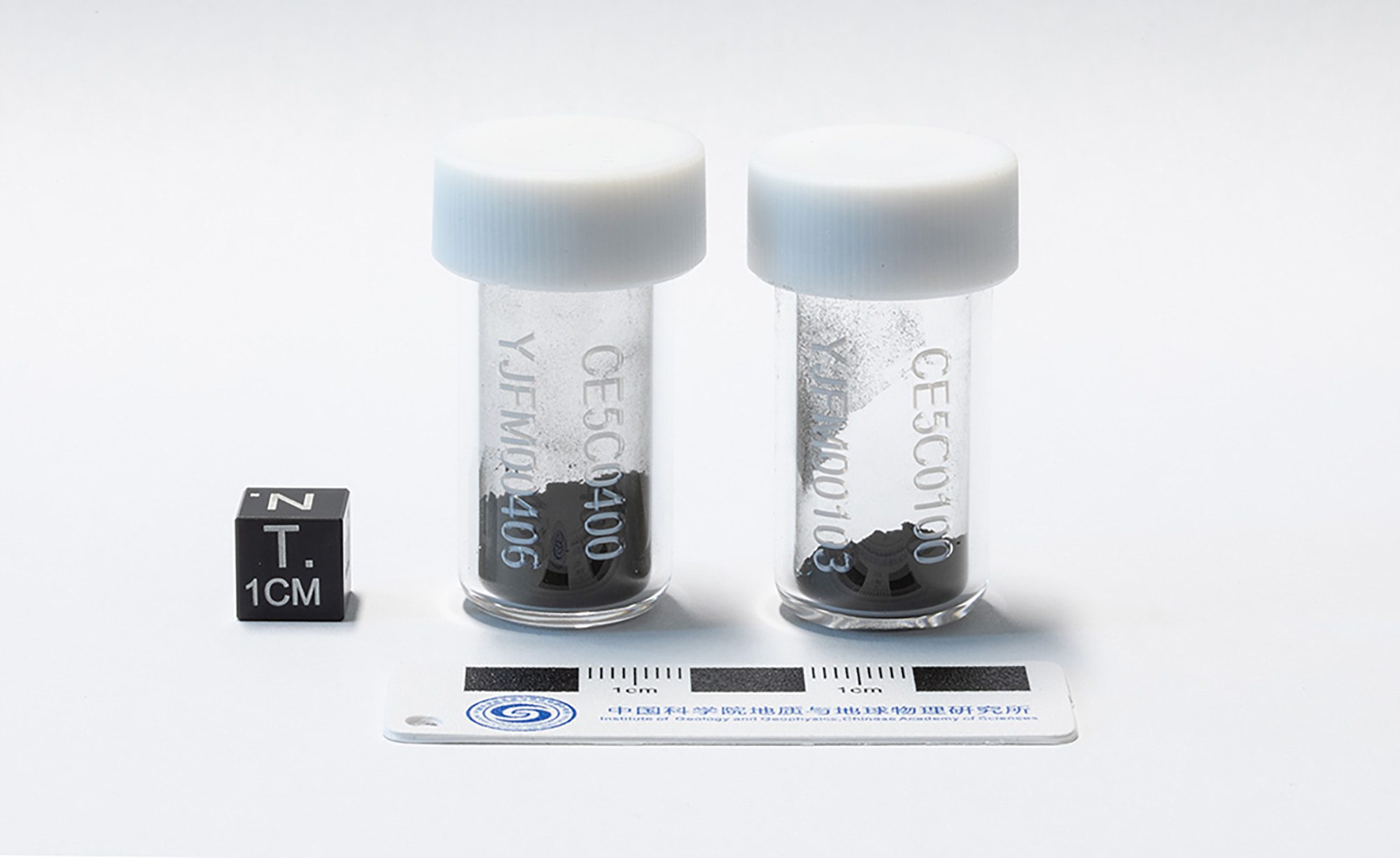
That December, Chang’e-5 touched down in the moon’s Ocean of Storms, a realm of frozen lava 1,600 miles long. It grabbed some 2-billion-year-old rocks, put them in a rocket, and blasted them into the firmament. The samples were captured by a small orbiting spacecraft; crucially, the idea was not all that dissimilar from how MSR imagined catching its own samples, baseball-glove style. China’s lunar haul was then dropped off back on Earth just before Christmas. It marked the first time since 1976 that samples had been returned from the moon, and the mission was seamless. 

two labelled vials of soil next to a small ruler for scale
China brought back soil samples from the moon’s Ocean of Storms during its Chang’e-5 mission, marking the first time since 1976 that samples had been returned from the moon.
WIKIMEDIA COMMONS

That same year, China made its first foray toward Mars. The project was called Tianwen-1, meaning “Questions to Heaven”—the first in a new series of audacious space missions to the Red Planet and orbiting asteroids. While its success was far from guaranteed, China was willing to kick into high gear immediately, sending both an orbiting spacecraft and a rover to Mars at the same time. No other country had ever managed to perform this act of spaceflight acrobatics on its first try.


Just as China ramped up its space schemes, some people in the scientific community began to wonder if NASA was (inadvertently) promising too much with MSR—and whether the heist would be worth the cost.

In 2020, the price tag for the program had jumped from an already expensive $5.3 billion to an estimated $7 billion. (For context, NASA’s Near-Earth Object Surveyor mission, which is currently being pieced together, has a price tag of around $1.2 billion. This space observatory is designed to find Earthbound asteroids and is tasked with defending all 8 billion of us from a catastrophic impact.)

But Perseverance was already on its way to Mars. It wasn’t as if this expensive train could go back to the station. The project’s advocates just hoped it’d actually make it there in one piece. 

While the US had previously entered Martian orbit successfully, several other entry, descent, and landing attempts on the planet had ended in explosive disaster; the primary antagonist is the Martian atmosphere, which can cause spacecraft to tumble wildly out of control or heat up and ignite. Perseverance would be traveling at nearly 12,500 miles per hour as it entered Mars’s airspace, and to land it’d need to decelerate, deploy a parachute, fire several rockets, and pilot itself to the skies above Jezero Crater—before a levitating crane would drop off the actual rover. 

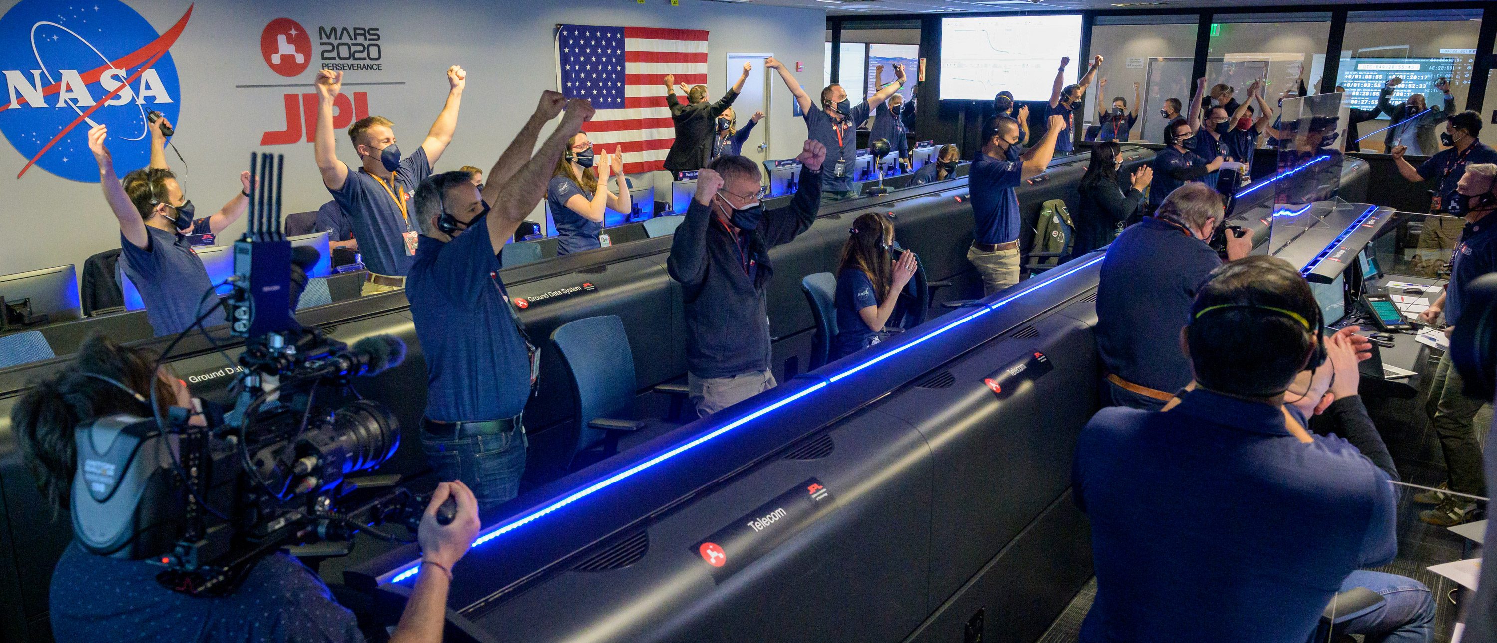
Thankfully, Perseverance’s deployment went off without a hitch. On February 18, 2021, Mars became its new home—and the rover’s makers hugged, high-fived, and whooped for joy in NASA’s flight control room. 

As Lori Glaze, then director of NASA’s planetary science division, said at the time, “Now the fun really starts.”

Members of NASA’s Perseverance rover team at the Jet Propulsion Laboratory in Pasadena, California, celebrate after receiving confirmation that the spacecraft successfully touched down on Mars in February 2021.
NASA/BILL INGALLS

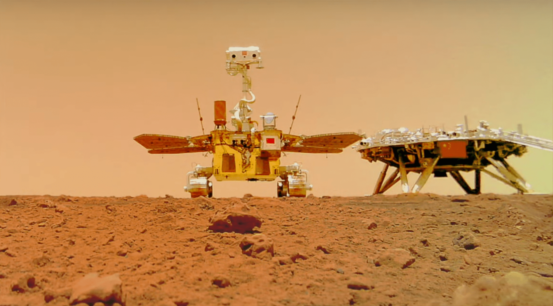
That very same month, China arrived at Mars’s doorstep for the first time. 

On February 10, 2021, Tianwen-1 began to orbit the planet. Then, on May 14, it slipped a drop shipment through the spacecraft-frying atmosphere to deliver a rover onto an expansive landscape called Utopia Planitia—giving Perseverance a neighbor, albeit one 1,200 miles away.

This explorer was nowhere near as sophisticated as Perseverance, and its assignment was a far cry from a sample return mission. It had some cameras and scientific instruments for studying its environment, making it comparable to one of NASA’s older rovers. It was also supposed to operate for just three months (though it ended up persisting for an entire year before being fatally smothered by pernicious Martian dust). 

Nevertheless, Tianwen-1 was a remarkable achievement for China, one that the US couldn’t help but applaud. “This is a really big deal,” said Roger Launius, then NASA’s chief historian.  

And even if grabbing pieces of Mars was increasingly likely in China’s future, it was already happening in the present for the US. The race, the Americans thought, was over before it had even begun … right? 


Over the next few years, Perseverance went on an extraterrestrial joyride. It meandered through frozen flows of lava and journeyed over fans of sediment once washed about by copious liquid water. It pulled out rocks that preserved salty, muddy layers—exactly the environment that, on Earth, would be teeming with microorganisms and organic matter. 

“Jezero Crater clearly meets the astrobiological criterion for a sampling site where life may once have existed,” says Lunine from NASA’s Jet Propulsion Lab. “Rocks of broadly similar age and setting on Earth contain some of the earliest evidence for life on our own planet.” 

The Perseverance rover has been on an extraterrestrial joyride since 2021, drilling holes in promising looking space rocks that it hopes could be teeming with microorganisms and organic matter.
AP IMAGES

Then, in September 2023, as Perseverance was trundling across the ruins of what may once have been a microbial metropolis, an independent panel of researchers published a report that made it clear, in no uncertain terms, that MSR was the opposite of okay.

They found that the project was too decentralized among the nation’s plethora of NASA centers, leaving confusion as to who was actually in charge. And at its current pace, MSR wouldn’t get its Mars rocks back home until the 2040s at the earliest—as much as a whole decade later than initial estimates. And it would cost as much as $11 billion, more than doubling the initial tab. 

“MSR was established with unrealistic budget and schedule expectations from the beginning,” the report reads. “MSR was also organized under an unwieldy structure. As a result, there is currently no credible, congruent technical, nor properly margined schedule, cost, and technical baseline that can be accomplished with the likely available funding.”

Members of Congress started to wonder aloud whether MSR should be canceled outright, and the scientific community that had once so enthusiastically supported the mission faced a moment of reckoning. 

Byrne, the planetary scientist from the Washington University in St. Louis, had always been something of a rebel, never really a fan of NASA’s multi-decadal, over-the-top fascination with Mars. The solar system, he argued, is filled with curious worlds to explore—especially Venus, another nearby rocky world that was once rather Earth-like. Couldn’t we spare some of NASA’s budget to make sure we explore Venus, too?

Still, like many other critical colleagues, Byrne did not want to see MSR put down. The report’s findings didn’t change the fact that Perseverance was dutifully working around the clock to accomplish the mission’s opening stages. What would be the point of gathering all those samples if they were going to be left to stay on Mars? The community, Byrne explains, just needed to answer one question: “How do you do this in a way that’s faster and cheaper?” 

In April 2024, NASA publicly sought help from its industry partners in the space sector: Could anyone come up with a way to save MSR? Various players with spaceflight experience, like Lockheed Martin, sent in proposals for consideration. 

Then, just a few months later in July 2024, Perseverance came in clutch, finding those special leopard-spotted and speckled rocks in an old river valley—a sign of hope that NASA had been desperately seeking. Now the agency’s request for help was all the more urgent—these rocks had to get home. After various panels assessed plans that could effectively save MSR, two potential options for a faster, leaner, less expensive version were previewed at a January 2025 press briefing. 

One option brought in tried-and-tested tech: Since Perseverance had been safely deployed onto the surface of Mars using a hovering platform known as a sky crane, it was proposed that the sample-gathering lander for MSR could also be dropped off using a sky crane, which would simplify this step and reduce the overall cost of the program. The other suggestion was that the lander could be delivered to Mars via a spaceship from a commercial spaceflight company. The lander design itself could also be streamlined, and tweaks could be made to the rocket that would launch the samples back into space.

The proposals needed greater study, but everyone’s spirits were lifted by the fact these plans could, at least theoretically, get samples back in the 2030s, not the 2040s. And, crucially, “it was possible to get the cost down,” says Jack Mustard, an Earth and planetary scientist at Brown University and a member of one of the two proposal-reviewing panels. Still, it didn’t save a lot: They could do MSR for $8 billion.

“What we came up with was very reasonable, rational, much simpler,” says Christensen, who was part of the same review panel. “And $8 billion is about the right amount it would take to guarantee that it’s going to work.”

XINMEI LIU

While the US became increasingly consumed with its own interplanetary woes, China was riding high.

In June 2024, the sixth installment in the Chang’e project made history. It was another lunar sample return mission, but this one did something nobody had ever done in the history of spaceflight: It landed on the difficult-to-reach, out-of-view far side of the moon and snagged samples from it. 

China made it look effortless when a capsule containing matter from this previously untouched region safely landed in Inner Mongolia. Long Xiao, a planetary geoscientist at the China University of Geosciences, told reporters at the time that the mission’s success was “a cause for celebration for all humanity.” 

But it was also effectively a bombshell for NASA. Yes, the moon is much closer to Earth, and it doesn’t have a spaceship-destroying atmosphere like Mars. But China was speedrunning through the race while America was largely looking the other way.

Then, in May 2025, China launched Tianwen-2. Its destination was not Mars but a near-Earth asteroid. The plan is that it will scoop up some of the space rock’s primordial pebbles later this year and deliver them back to Earth in late 2027. In light of China’s past successes, many suspect it’ll nail this project, too. 

Tianwen-2 on the launchpad
China’s Tianwen missions, meaning “Questions to Heaven,” aim to explore both Mars and orbiting asteroids. The Tianwen-2 probe blasted off in May 2025, headed toward a near-Earth asteroid for a sample-return mission.
VCG/VCG VIA AP IMAGES

But perhaps the biggest blow to the US came in June 2025: China revealed its formal designs on returning samples from Mars—and potentially addressing the existence of life elsewhere in the cosmos. Chinese researchers outlined a bold plan for Tianwen-3 in the journal Nature Astronomy. “Searching for signs of life, or astrobiology studies, are the first priority,” says Yuqi Qian, a lunar geologist at the University of Hong Kong. And while many observers had long been cognizant of this ambition, seeing it so clearly spelled out in academic writing made it real.

“The selection of the landing site is still ongoing,” says Li Yiliang, an astrobiologist at the University of Hong Kong, an author of the Tianwen-3 study, and a member of the spacecraft’s landing site selection team. But the paper notes, in no uncertain terms, that the mission will move at a breakneck pace. “The aim of China’s Mars sample return mission, known as Tianwen-3, is to collect at least 500g of samples from Mars and return them to Earth around 2031.”

2031. Even on its original, speedier timeline, America’s MSR plan wouldn’t get samples back by that date. So how is China planning to pull it off?

Qian explains that Tianwen-3 is building on the success of the lunar sample return program. Doing something similar for Mars is a rather giant technological leap (requiring two rockets, not one)—but, he argues, “the technologies here are similar.” 

The plan is for a duet of rockets to blast off from Earth in 2028. The first will contain the lander-ascender combination, or LAC. The second is the orbiter-returner combination, or ORC. The LAC will get to Mars and deploy a lander as well as a small helicopter, which will scout promising locations around the landing site while using a claw to bring several small samples back to the lander.

China’s Tianwen-3 mission is searching for signs of Martian life with an eye toward having samples back home sometime in 2031.
中国新闻社 VIA WIKIMEDIA COMMONS

The LAC will then travel to the most promising site. The lander’s drill, which can get down to around seven feet below the surface, is the most important part of the mission. At that depth, there are greater odds of capturing signs of past life. When at least 500 grams of pristine rocks have been loaded aboard the lander, the samples will be launched into space, where the orbiter will be waiting to capture them and send them back home sometime in 2031.

“The returned samples will be quarantined strictly in an under-planning facility near Hefei city,” says Yiliang. And there, in those bio-secure labs, scientists might very well find the first clear signs of alien life, past or present.


The very same month that Chinese researchers published their daring plans for returning Mars samples, the new Trump administration released a draconian NASA budget for Congress to consider—one that sparked panic across the planetary science community.

If enacted, it would have been a historic catastrophe for the venerable space agency, giving NASA its smallest budget since 1961. This would have forced it to let go of a huge number of staffers, slash its science program budget in half, and terminate 19 missions currently in operation. MSR was in the crosshairs, too. 

“Grim is the word,” says Dreier of the Planetary Society. 

Over the next few months, Congress pushed back on the potential gutting of NASA, but largely to save ongoing solar system exploration missions. MSR was not considered an active effort; Perseverance was effectively a scientific scout acting independently by this point. A counterproposal by the House offered up $300 million for MSR, but no policymaker was cheerleading for it. (The US Office of Management and Budget, the House Committee on Science, Space, and Technology, and the office of Sen. Ted Cruz of Texas, who chairs the Senate Committee on Commerce, Science, and Transportation did not respond to requests for comment.)

“Mars Sample Return doesn’t seem to have very many advocates right now,” says Byrne. The project “isn’t featuring in anyone’s conversation at the moment, with all of the existential shit that’s happening to NASA.” Everyone working on a NASA mission hoped that they, and their spacecraft, would survive the onslaught. As Byrne adds: “[People are] just trying to keep their heads down.”

Researchers in America suddenly found themselves at an inflection point. “The attack on science, and the attack on NASA science, has been very successful, in that it has completely demoralized the science community,” says Christensen. “Everyone’s in a state of shock.” 

When I contacted NASA in July about the state of MSR, which was then in the middle of a months-long limbo, I was told that experts weren’t available to comment. Roxana Bardan, a spokesperson, instead sent a statement: “Under President Trump’s America First agenda, NASA is committed to sustained U.S. space leadership. We will continue to innovate, explore, and excel to ensure American preeminence in space.” (The agency did not respond to a follow-up request for comment.) 

That notion stood in direct contrast to what Christensen told me around the same time. “The US … has led the exploration of Mars for 50 years,” he said. “And as we approach one of the key discovery points, we’re about to concede that leadership to someone else.”


From China’s perspective, the fumbling of MSR is more confusing than anything else. “NASA has so well prepared for her MSR mission in both technology and science, and I and my colleagues have learned so much from NASA’s scientific communities,” says Yiliang. 

And if China wins the race because America decided to shoot itself in the foot? “This is sad,” he says. “If this comes true, I believe the Chinese will not be that happy to win the race in this way.”

Tianwen-3 will still have to overcome many of the same hurdles as MSR. Nobody, for example, has autonomously launched a rocket of any kind off the surface of Mars. But many believe the Chinese can succeed, even at their program’s superspeed. Christensen, for one, fully expected several of their past robotic missions to the moon and Mars to fail—but “the fact that they pulled it off the first time really says a lot about their engineering capability,” he says. 

Mustard agrees: “They know how to land; they know how to leave. I have a lot of confidence that they’ve learned enough from the lunar work that they’ll be able to do it.”

Plus, Tianwen-3’s architecture is simpler than the US-European mission. It has fewer components, and fewer points of potential failure. This also means, though, that the quality of the loot will be somewhat lacking. Tianwen-3 will sample from only one small patch of Mars. Conversely, Perseverance is roving around a vast and geologically diverse landscape, sampling as it goes, which would translate to “literally orders of magnitude more science than what will come from the Chinese samples,” says Christensen.

But China could serendipitously land on a biologically rich patch of the planet. As the Southwest Research Institute’s Hamilton says, the mission could “pick up something entirely unexpected and, you know, miraculous.” 

The likeliest outcome is still that neither nation finds fossilized microbes, but that China brings back rocks from Mars first. At the end of the day, that’s what Americans (and Europeans) will hear: “You’re second. You lost,” says Mustard.

Like many of his colleagues, Christensen is irked by the thought of losing the race to Mars, because it would be such an own goal. The US has been sending robots over there for decades and investing billions in forging the technology that would be required to make MSR a success. And suddenly “the Chinese come along and say, Thank you very much, we’ll take all of that information—we’ll build one mission and go and do what you guys did the groundwork for,” Christensen says. “As a taxpayer, I’m like: It just seems foolish to me.”

Even the MSR skeptics concede that this kind of loss would have sweeping ramifications. Byrne worries that if something like MSR can be snuffed out so easily, what’s to say the next big mission—to Jupiter, Saturn, and beyond—won’t suffer the same ignoble fate? In other words, the death of MSR would severely damage “the ability of the planetary community to dream big,” he says. “If we don’t pull this off, what does that mean? Are we not going to do big, expensive, difficult things?”

Another big, expensive, difficult thing? Putting humans on Mars. Both critics and advocates of MSR largely agree it is an invaluable dress rehearsal. Making sure you can safely launch a rocket off Mars is a necessary prerequisite to ensuring that an array of equipment can survive for a long time on the planet’s lethal surface.

China, too, has explicitly acknowledged this. As one of the first lines of the Tianwen-3 study states, “Mars is the most promising planet for humanity’s expansion beyond Earth, with its potential for future habitability and accessible resources.” 

Though such expansion is still of course a far-future dream, it’s not hard to see how losing the race here would put the US at a huge disadvantage. Members of America’s planetary science community say that to try to sway politicians in their favor, they have framed MSR as a national security issue. But they haven’t had much luck. “We’ve been in discussions with decision-makers who have never heard that perspective before,” says the Planetary Society’s Dreier. 

“It is surprising that doesn’t have more weight,” adds Mustard. 

Despite months of purgatory, it still stung when the coup de grâce arrived in January. In the draft for a must-pass spending bill, House and Senate appropriators spared NASA from the harshest proposed cuts, thereby saving dozens of spaceflight missions and preserving much of the agency’s planetary science output. But the bill provided absolutely zero political or financial support for MSR. There it was, in black and white: America’s plans to perform a history-making heist on Mars were dead. The bill became law in January and Perseverance, it seems, is now destined to rove alone on the Red Planet until its nuclear battery burns out. 

This austere reality clashes with the soaring aspirations outlined in the first Planetary Decadal Survey, written just over two decades ago. It stated that the US exploration of the solar system “has a proud past, a productive present, and an auspicious future.” It also noted that “answers to profound questions about our origins and our future may be within our grasp.” 

Now the answers have all but slipped away. Even though Perseverance continues to roam, it’s increasingly likely we’ll never see those promising bespeckled rocks with human eyes, let alone any other rocks the rover finds intriguing. It is far easier to imagine that in the near future, perhaps in the early 2030s, Perseverance will point its camera up at the night sky above Jezero Crater. It will catch a small glimmer: Tianwen-3’s orbiter, preparing to send ancient rocks back to Earth. Meanwhile, Perseverance’s own sample tubes—perhaps some containing signs of life—will be trapped on the Martian surface, gathering dust.

Sample tubes collected by the Perseverance rover may never make it home from the Martian surface.
NASA/JPL-CALTECH/MSSS

It is a sobering thought for Christensen. “We’ll wake up one day and go: What the hell?” he says. “How did we let this happen?”

Robin George Andrews is an award-winning science journalist and doctor of volcanoes based in London. He regularly writes about the Earth, space, and planetary sciences, and is the author of two critically acclaimed books: Super Volcanoes (2021) and How to Kill An Asteroid (2024).

The astronaut training tourists to fly in the world’s first commercial space station

For decades, space stations have been largely staffed by professional astronauts and operated by a handful of nations. But that’s about to change in the coming years, as companies including Axiom Space and Sierra Space launch commercial space stations that will host tourists and provide research facilities for nations and other firms. 

The first of those stations could be Haven-1, which the California-based company Vast aims to launch in May 2026. If all goes to plan, its earliest paying visitors will arrive about a month later. Drew Feustel, a former NASA astronaut, will help train them and get them up to speed ahead of their historic trip. Feustel has spent 226 days in space on three trips to the International Space Station (ISS) and the Hubble Space Telescope. 

Feustel is now lead astronaut for Vast, which he advised on the new station’s interior design. He also created a months-long program to prepare customers to live and work there. Crew members (up to four at a time) will arrive at Haven-1 via a SpaceX Dragon spacecraft, which will dock to the station and remain attached throughout each 10-day stay. (Vast hasn’t publicly said who will fly on its first missions or announced the cost of a ticket, though competing firms have charged tens of millions of dollars for similar trips.)

In this artist’s rendering, the Haven-1 space station is shown in orbit docked with the SpaceX Dragon spacecraft.
VAST

Haven-1 is intended as a temporary facility, to be followed by a bigger, permanent station called Haven-2. Vast will begin launching Haven-2’s modules in 2028 and says it will be able to support a crew by 2030. That’s about when NASA will start decommissioning the ISS, which has operated for almost 30 years. Instead of replacing it, NASA and its partners intend to carry out research aboard commercial stations like those built by Vast, Axiom, and Sierra. 

I recently caught up with Feustel in Lisbon at the tech conference Web Summit, where he was speaking about his role at Vast and the company’s ambitions. 

Responses have been edited and condensed. 

What are you hoping this new wave of commercial space stations will enable people to do?

Ideally, we’re creating access. The paradigm that we’ve seen for 25 years is primarily US-backed missions to the International Space Station, and [NASA] operating that station in coordination with other nations. But [it’s] still limited to 16 or 17 primary partners in the ISS program. 

Following NASA’s intentions, we are planning to become a service provider to not only the US government, but other sovereign nations around the world, to allow greater access to a low-Earth-orbit platform. We can be a service provider to other organizations and nations that are planning to build a human spaceflight program.

Today, you’re Vast’s lead astronaut after you were initially brought on to advise the company on the design of Haven-1 and Haven-2. What are some of the things that you’ve weighed in on? 

Some of the things where I can see tangible evidence of my work is, for example, in the sleep cores and sleep system—trying to define a more comfortable way for astronauts to sleep. We’ve come up with an air bladder system that provides distributed forces on the body that kind of emulate, or I believe will emulate, the gravity field that we feel in bed when we lie down, having that pressure of gravity on you. 

Oh, like a weighted blanket? 

Kind of like a weighted blanket, but you’re up against the wall, so you have to create, like, an inflatable bladder that will push you against the wall. That’s one of the very tangible, obvious things. But I work with the company on anything from crew displays and interfaces and how notifications and system information come through to how big a window should be. 

How big should a window be? I feel like the bigger the betterbut what are the factors that go into that, from an astronaut’s perspective? 

The bigger the better. And the other thing to think about is—what do you do with the window? Take pictures. The ability to take photos out a window is important—the quality of the window, which direction it points. You know, it’s not great if it’s just pointing up in space all the time and you never see the Earth. 

A person looks out the window of Haven-1 at the Earth.

VAST

You’re also in charge of the astronaut training program at Vast. Tell me what that program looks like, because in some cases you’ll have private citizens who are paying for their trip that have no experience whatsoever.

A typical training flow for two weeks on our space station is extended out to about an 11-month period with gaps in between each of the training weeks. And so if you were to press that down together, it probably represents about three to four months of day-to-day training. 

I would say half of it’s devoted to learning how to fly on the SpaceX Dragon, because that’s our transportation, and the greatest risk for anybody flying is on launch and landing. We want people to understand how to operate in that spacecraft, and that component is designed by SpaceX. They have their own training plans. 

What we do is kind of piggyback on those weeks. If a crew shows up in California to train at SpaceX, we’ll grab them that same week and say, “Come down to our facility. We will train you to operate inside our spacecraft.” Much of that is focused on emergency response. We want the crew to be able to keep themselves safe. In case anything happens on the vehicle that requires them to depart, to get back in the SpaceX Dragon and leave, we want to make sure that they understand all of the steps required. 

Another part is day-to-day living, like—how do you eat? How do you sleep, how do you use the bathroom? Those are really important things. How do you download the pictures after you take them? How do you access your science payloads that are in our payload racks that provide data and telemetry for the research you’re doing? 

We want to practice every one of those things multiple times, including just taking care of yourself, before you go to space so that when you get there, you’ve built a lot of that into your muscle memory, and you can just do the things you need to do instead of every day being like a really steep learning curve.

VAST

Strawberries and other perishable foods are freeze-dried by the Vast Food Systems team to prepare them for missions.

Making coffee in a zero-gravity environment calls for specialized devices.
VAST

Do you have a facility where you’ll take people through some of these motions? Or a virtual simulation of some kind? 

We have built a training mock-up, an identical vehicle to what people will live in in space. But it’s not in a zero-gravity environment. The only way to get any similar training is to fly on what we call a zero-g airplane, which does parabolas in space—it climbs up and then falls toward the Earth. Its nickname is the vomit comet. 

But otherwise, there’s really no way to train for microgravity. You just have to watch videos and talk about it a lot, and try to prepare people mentally for what that’s going to be like. You can also train underwater, but that’s more related to spacewalking, and it’s much more advanced. 

How do you expect people will spend their time in the station? 

If history is any indication, they will be quite busy and probably oversubscribed. Their time will be spent basically caring for themselves, and trying to execute their experiments, and looking out the window. Those are the three big categories of what you’re going to do in space. And public relation activities like outreach back to Earth, to schools or hospitals or corporations. 

This new era means that many more everyday people—though mostly wealthy ones at the beginning, because of ticket prices—will have this interesting view of Earth. How do you think the average person will react to that? 

A good analogy is to say, how are people reacting to sub-orbital flights? Blue Origin and Virgin Galactic offer suborbital flights, [which are] basically three or four minutes of floating and looking down at the Earth from an altitude that’s about a third or a fifth of the altitude that actual orbital and career astronauts achieve when they circle the planet. 

Shown here is Vast’s Haven-1 station as it completes testing in the Mojave Desert in 2025.
VAST

If you look at the reaction of those individuals and what they perceive, it’s amazing, right? It’s like awe and wonder. It’s the same way that astronauts react and talk when we see Earth—and say if more humans could see Earth from space, we’d probably be a little bit better about being humans on Earth. 

That’s the hope, is that we create that access and more people can understand what it means to live on this planet. It’s essentially a spacecraft—it’s got its own environmental control system that keeps us alive, and that’s a big deal. 

Some people have expressed ambitions for this kind of station to enable humans to become a multiplanetary species. Do you share that ambition for our species? If so, why? 

Yeah, I do. I just believe that humans need to have the ability to live off of the planet. I mean, we’re capable of it, and we’re creating that access now. So why wouldn’t we explore space and go further and farther and learn to live in other areas?

Not to say that we should deplete everything here and deplete everything there. But maybe we take some of the burden off of the place that we call home. I think there’s a lot of reasons to live and work in space and off our own planet. 

There’s not really a backup plan for no Earth. We know that there are risks from the space around us—dinosaurs fell prey to space hazards. We should be aware of those and work harder to extend our capabilities and create some backup plans. 

Southeast Asia seeks its place in space
thailand highlighted on a globe
__________________________
Thai Space Expo
October 16-18, 2025
___
Bangkok, Thailand

It’s a scorching October day in Bangkok and I’m wandering through the exhibits at the Thai Space Expo, held in one of the city’s busiest shopping malls, when I do a double take. Amid the flashy space suits and model rockets on display, there’s a plain-looking package of Thai basil chicken. I’m told the same kind of vacuum-­sealed package has just been launched to the International Space Station.

“This is real chicken that we sent to space,” says a spokesperson for the business behind the stunt, Charoen Pokphand Foods, the biggest food company in Thailand.

It’s an unexpected sight, one that reflects the growing excitement within the Southeast Asian space sector. At the expo, held among designer shops and street-food stalls, enthusiastic attendees have converged from emerging space nations such as Vietnam, Malaysia, Singapore, and of course Thailand to showcase Southeast Asia’s fledgling space industry.

While there is some uncertainty about how exactly the region’s space sector may evolve, there is plenty of optimism, too. “Southeast Asia is perfectly positioned to take leadership as a space hub,” says Candace Johnson, a partner in Seraphim Space, a UK investment firm that operates in Singapore. “There are a lot of opportunities.”

A sample package of pad krapow was also on display.
COURTESY OF THE AUTHOR

For example, Thailand may build a spaceport to launch rockets in the next few years, the country’s Geo-Informatics and Space Technology Development Agency announced the day before the expo started. “We don’t have a spaceport in Southeast Asia,” says Atipat Wattanuntachai, acting head of the space economy advancement division at the agency. “We saw a gap.” Because Thailand is so close to the equator, those rockets would get an additional boost from Earth’s rotation.

All kinds of companies here are exploring how they might tap into the global space economy. VegaCosmos, a startup based in Hanoi, Vietnam, is looking at ways to use satellite data for urban planning. The Electricity Generating Authority of Thailand is monitoring rainstorms from space to predict landslides. And the startup Spacemap, from Seoul, South Korea, is developing a new tool to better track satellites in orbit, which the US Space Force has invested in.

It’s the space chicken that caught my eye, though, perhaps because it reflects the juxtaposition of tradition and modernity seen across Bangkok, a city of ancient temples nestled next to glittering skyscrapers.

In June, astronauts on the space station were treated to this popular dish, known as pad krapow. It’s more commonly served up by street vendors, but this time it was delivered on a private mission operated by the US-based company Axiom Space. Charoen Pokphand is now using the stunt to say its chicken is good enough for NASA (sadly, I wasn’t able to taste it to weigh in).

Other Southeast Asian industries could also lend expertise to future space missions. Johnson says the region could leverage its manufacturing prowess to develop better semiconductors for satellites, for example, or break into the in-space manufacturing market.

I left the expo on a Thai longboat down the Chao Phraya River that weaves through Bangkok, with visions of astronauts tucking into some pad krapow in my head and imagining what might come next.

Jonathan O’Callaghan is a freelance space journalist based in Bangkok who covers commercial spaceflight, astrophysics, and space exploration.

What is the chance your plane will be hit by space debris?

MIT Technology Review Explains: Let our writers untangle the complex, messy world of technology to help you understand what’s coming next. You can read more from the series here.

In mid-October, a mysterious object cracked the windshield of a packed Boeing 737 cruising at 36,000 feet above Utah, forcing the pilots into an emergency landing. The internet was suddenly buzzing with the prospect that the plane had been hit by a piece of space debris. We still don’t know exactly what hit the plane—likely a remnant of a weather balloon—but it turns out the speculation online wasn’t that far-fetched.

That’s because while the risk of flights being hit by space junk is still small, it is, in fact, growing. 

About three pieces of old space equipment—used rockets and defunct satellites—fall into Earth’s atmosphere every day, according to estimates by the European Space Agency. By the mid-2030s, there may be dozens. The increase is linked to the growth in the number of satellites in orbit. Currently, around 12,900 active satellites circle the planet. In a decade, there may be 100,000 of them, according to analyst estimates.

To minimize the risk of orbital collisions, operators guide old satellites to burn up in Earth’s atmosphere. But the physics of that reentry process are not well understood, and we don’t know how much material burns up and how much reaches the ground.

“The number of such landfall events is increasing,” says Richard Ocaya, a professor of physics at the University of Free State in South Africa and a coauthor of a recent paper on space debris risk. “We expect it may be increasing exponentially in the next few years.”

So far, space debris hasn’t injured anybody—in the air or on the ground. But multiple close calls have been reported in recent years. In March last year, an 0.7-kilogram chunk of metal pierced the roof of a house in Florida. The object was later confirmed to be a remnant of a battery pallet tossed out from the International Space Station. When the strike occurred, the homeowner’s 19-year-old son was resting in a next-door room.

And in February this year, a 1.5-meter-long fragment of SpaceX’s Falcon 9 rocket crashed down near a warehouse outside Poland’s fifth-largest city, Poznan. Another piece was found in a nearby forest. A month later, a 2.5-kilogram piece of a Starlink satellite dropped on a farm in the Canadian province of Saskatchewan. Other incidents have been reported in Australia and Africa. And many more may be going completely unnoticed. 

“If you were to find a bunch of burnt electronics in a forest somewhere, your first thought is not that it came from a spaceship,” says James Beck, the director of the UK-based space engineering research firm Belstead Research. He warns that we don’t fully understand the risk of space debris strikes and that it might be much higher than satellite operators want us to believe. 

For example, SpaceX, the owner of the currently largest mega-constellation, Starlink, claims that its satellites are “designed for demise” and completely burn up when they spiral from orbit and fall through the atmosphere.

But Beck, who has performed multiple wind tunnel tests using satellite mock-ups to mimic atmospheric forces, says the results of such experiments raise doubts. Some satellite components are made of durable materials such as titanium and special alloy composites that don’t melt even at the extremely high temperatures that arise during a hypersonic atmospheric descent. 

“We have done some work for some small-satellite manufacturers and basically, their major problem is that the tanks get down,” Beck says. “For larger satellites, around 800 kilos, we would expect maybe two or three objects to land.” 

It can be challenging to quantify how much of a danger space debris poses. The International Civil Aviation Organization (ICAO) told MIT Technology Review that “the rapid growth in satellite deployments presents a novel challenge” for aviation safety, one that “cannot be quantified with the same precision as more established hazards.” 

But the Federal Aviation Administration has calculated some preliminary numbers on the risk to flights: In a 2023 analysis, the agency estimated that by 2035, the risk that one plane per year will experience a disastrous space debris strike will be around 7 in 10,000. Such a collision would either destroy the aircraft immediately or lead to a rapid loss of air pressure, threatening the lives of all on board.

The casualty risk to humans on the ground will be much higher. Aaron Boley, an associate professor in astronomy and a space debris researcher at the University of British Columbia, Canada, says that if megaconstellation satellites “don’t demise entirely,” the risk of a single human death or injury caused by a space debris strike on the ground could reach around 10% per year by 2035. That would mean a better than even chance that someone on Earth would be hit by space junk about every decade. In its report, the FAA put the chances even higher with similar assumptions, estimating that “one person on the planet would be expected to be injured or killed every two years.”

Experts are starting to think about how they might incorporate space debris into their air safety processes. The German space situational awareness company Okapi Orbits, for example, in cooperation with the German Aerospace Center and the European Organization for the Safety of Air Navigation (Eurocontrol), is exploring ways to adapt air traffic control systems so that pilots and air traffic controllers can receive timely and accurate alerts about space debris threats.

But predicting the path of space debris is challenging too. In recent years, advances in AI have helped improve predictions of space objects’ trajectories in the vacuum of space, potentially reducing the risk of orbital collisions. But so far, these algorithms can’t properly account for the effects of the gradually thickening atmosphere that space junk encounters during reentry. Radar and telescope observations can help, but the exact location of the impact becomes clear with only very short notice.

“Even with high-fidelity models, there’s so many variables at play that having a very accurate reentry location is difficult,” says Njord Eggen, a data analyst at Okapi Orbits. Space debris goes around the planet every hour and a half when in low Earth orbit, he notes, “so even if you have uncertainties on the order of 10 minutes, that’s going to have drastic consequences when it comes to the location where it could impact.”

For aviation companies, the problem is not just a potential strike, as catastrophic as that would be. To avoid accidents, authorities are likely to temporarily close the airspace in at-risk regions, which creates delays and costs money. Boley and his colleagues published a paper earlier this year estimating that busy aerospace regions such as northern Europe or the northeastern United States already have about a 26% yearly chance of experiencing at least one disruption due to the reentry of a major space debris item. By the time all planned constellations are fully deployed, aerospace closures due to space debris hazards may become nearly as common as those due to bad weather.

Because current reentry predictions are unreliable, many of these closures may end up being unnecessary.

For example, when a 21-metric-ton Chinese Long March mega-rocket was falling to Earth in 2022, predictions suggested its debris could scatter across Spain and parts of France. In the end, the rocket crashed into the Pacific Ocean. But the 30-minute closure of south European airspace delayed and diverted hundreds of flights. 

In the meantime, international regulators are urging satellite operators and launch providers to deorbit large satellites and rocket bodies in a controlled way, when possible, by carefully guiding them into remote parts of the ocean using residual fuel. 

The European Space Agency estimates that only about half the rocket bodies reentering the atmosphere do so in a controlled way. 

Moreover, around 2,300 old and no-longer-controllable rocket bodies still linger in orbit, slowly spiraling toward Earth with no mechanisms for operators to safely guide them into the ocean.

“There’s enough material up there that even if we change our practices, we will still have all those rocket bodies eventually reenter,” Boley says. “Although the probability of space debris hitting an aircraft is small, the probability that the debris will spread and fall over busy airspace is not small. That’s actually quite likely.”

Inside the archives of the NASA Ames Research Center

At the southern tip of San Francisco Bay, surrounded by the tech giants Google, Apple, and Microsoft, sits the historic NASA Ames Research Center. Its rich history includes a grab bag of fascinating scientific research involving massive wind tunnels, experimental aircraft, supercomputing, astrobiology, and more.

Founded in 1939 as a West Coast lab for the National Advisory Committee for Aeronautics (NACA), NASA Ames was built to close the US gap with Germany in aeronautics research. Named for NACA founding member Joseph Sweetman Ames, the facility grew from a shack on Moffett Field into a sprawling compound with thousands of employees. A collection of 5,000 images from NASA Ames’s archives paints a vivid picture of bleeding-edge work at the heart of America’s technology hub. 

Wind tunnels

NASA AMES RESEARCH CENTER ARCHIVES

A key motivation for the new lab was the need for huge wind tunnels to jump-start America’s aeronautical research, which was far behind Germany’s. Smaller tunnels capable of speeds up to 300 miles per hour were built first, followed by a massive 40-by-80-foot tunnel for full-scale aircraft. Powered up in March 1941, these tunnels became vital after Pearl Harbor, helping scientists rapidly develop advanced aircraft.

Today, NASA Ames operates the world’s largest pressurized wind tunnel, with subsonic and transonic chambers for testing rockets, aircraft, and wind turbines.

Pioneer and Voyager 2

NASA AMES RESEARCH CENTER ARCHIVES

From 1965 to 1992, Ames managed the Pioneer missions, which explored the moon, Venus, Jupiter, and Saturn. It also contributed to Voyager 2, launched in 1977, which journeyed past four planets before entering interstellar space in 2018. Ames’s archive preserves our first glimpses of strange new worlds seen during these pioneering missions.

Odd aircraft

aircraft in flight

NASA AMES RESEARCH CENTER ARCHIVES

The skeleton of a hulking airship hangar, obsolete even before its completion, remains on NASA Ames’s campus.

Many odd-looking experimental aircraftsuch as vertical take-off and landing (VTOL) aircraft, jets, and rotorcrafthave been developed and tested at the facility over the years, and new designs continue to take shape there today.

Vintage illustrations

NASA AMES RESEARCH CENTER ARCHIVES

Awe-inspiring retro illustrations in the Ames archives depict surfaces of distant planets, NASA spacecraft descending into surreal alien landscapes, and fantastical renderings of future ring-shaped human habitats in space. The optimism and excitement of the ’70s and ’80s is evident. 

Bubble suits and early VR

person in an early VR suit

NASA AMES RESEARCH CENTER ARCHIVES

In the 1980s, NASA Ames researchers worked to develop next-generation space suits, such as the bulbous, hard-shelled AX-5 model. NASA Ames’s Human-Machine Interaction Group also did pioneering work in the 1980s with virtual reality and came up with some wild-­looking hardware. Long before today’s AR/VR boom, Ames researchers glimpsed the technology’s potentialwhich was limited only by computing power.

 Decades of federally funded research at Ames fueled breakthroughs in aviation, spaceflight, and supercomputingan enduring legacy now at risk as federal grants for science face deep cuts.

A version of this story appeared on Beau­tiful Public Data (beautifulpublicdata.com), a newsletter by Jon Keegan that curates visually interesting data sets collected by local, state, and federal government agencies.

An Earthling’s guide to planet hunting

The pendant on Rebecca Jensen-Clem’s necklace is only about an inch wide, composed of 36 silver hexagons entwined in a honeycomb mosaic. At the Keck Observatory, in Hawaii, just as many segments make up a mirror that spans 33 feet, reflecting images of uncharted worlds for her to study. 

Jensen-Clem, an astronomer at the University of California, Santa Cruz, works with the Keck Observatory to figure out how to detect new planets without leaving our own. Typically, this pursuit faces an array of obstacles: Wind, fluctuations in atmospheric density and temperature, or even a misaligned telescope mirror can create a glare from a star’s light that obscures the view of what’s around it, rendering any planets orbiting the star effectively invisible. And what light Earth’s atmosphere doesn’t obscure, it absorbs. That’s why researchers who study these distant worlds often work with space telescopes that circumvent Earth’s pesky atmosphere entirely, such as the $10 billion James Webb Space Telescope. 

But there’s another way over these hurdles. At her lab among the redwoods, Jensen-Clem and her students experiment with new technologies and software to help Keck’s primary honeycomb mirror and its smaller, “deformable” mirror see more clearly. Using measurements from atmospheric sensors, deformable mirrors are designed to adjust shape rapidly, so they can correct for distortions caused by Earth’s atmosphere on the fly. 

This general imaging technique, called adaptive optics, has been common practice since the 1990s. But Jensen-Clem is looking to level up the game with extreme adaptive optics technologies, which are aimed to create the highest image quality over a small field of view. Her group, in particular, does so by tackling issues involving wind or the primary mirror itself. The goal is to focus starlight so precisely that a planet can be visible even if its host star is a million to a billion times brighter.

In April, she and her former collaborator Maaike van Kooten were named co-recipients of the Breakthrough Prize Foundation’s New Horizons in Physics Prize. The prize announcement says they earned this early-career research award for their potential “to enable the direct detection of the smallest exo­planets” through a repertoire of methods the two women have spent their careers developing. 

In July, Jensen-Clem was also announced as a member of a new committee for the Habitable Worlds Observatory, a concept for a NASA space telescope that would spend its career on the prowl for signs of life in the universe. She’s tasked with defining the mission’s scientific goals by the end of the decade.

The Keck Observatory’s 10-meter primary mirror features a honeycomb structure with 36 individual mirror segments.
ETHAN TWEEDIE

“In adaptive optics, we spend a lot of time on simulations, or in the lab,” Jensen-Clem says. “It’s been a long road to see that I’ve actually made things better at the observatory in the past few years.”

Jensen-Clem has long appreciated astronomy for its more mind-bending qualities. In seventh grade, she became fascinated by how time slows down near a black hole when her dad, an aerospace engineer, explained that concept to her. After starting her bachelor’s degree at MIT in 2008, she became taken with how a distant star can seem to disappear—either suddenly winking out or gently fading away, depending on the kind of object that passes in front of it. “It wasn’t quite exoplanet science, but there was a lot of overlap,” she says.

“If you just look up at the night sky and see stars twinkling, it’s happening fast. So we have to go fast too.”

During this time, Jensen-Clem began sowing the seeds for one of her prize-winning methods after her teaching assistant recommended that she apply for an internship at NASA’s Jet Propulsion Laboratory. There, she worked on a setup that could perfect the orientation of a large mirror. Such mirrors are more difficult to realign than the smaller, deformable ones, whose shape-changing segments cater to Earth’s fluctuating atmosphere.

“At the time, we were saying, ‘Oh, wouldn’t it be really cool to install one of these at Keck Observatory?’” Jensen-Clem says. The idea stuck around. She even wrote about it in a fellowship application when she was gearing up to start her graduate work at Caltech. And after years of touch-and-go development, Jensen-Clem succeeded in installing the system—which uses a technology called a Zernike wavefront sensor—on Keck’s primary mirror about a year ago. “My work as a college intern is finally done,” she says. 

The system, which is currently used for occasional recalibrations rather than continuous adjustments, includes a special kind of glass plate that bends the light rays from the mirror to reveal a specific pattern. The detector can pick up a hairbreadth misalignment in that picture: If one hexagon is pushed too far back or forward, its brightness changes. Even the tiniest misalignment is important to correct, because “when you’re studying a faint object, suddenly you’re much more susceptible to little mistakes,” Jensen-Clem says.

She has also been working to perfect the craft of molding Keck’s deformable mirror. This instrument, which reflects light that’s been rerouted from the primary mirror, is much smaller—only six inches wide—and is designed to reposition as often as 2,000 times a second to combat atmospheric turbulence and create the clearest picture possible. “If you just look up at the night sky and see stars twinkling, it’s happening fast. So we have to go fast too,” Jensen-Clem says. 

Even at this rapid rate of readjustment, there’s still a lag. The deformable mirror is usually about one millisecond behind the actual outdoor conditions at any given time. “When the [adaptive optics] system can’t keep up, then you aren’t going to get the best resolution,” says van Kooten, Jensen-Clem’s former collaborator, who is now at the National Research Council Canada. This lag has proved especially troublesome on windy nights. 

Jensen-Clem thought it was an unsolvable problem. “The reason we have that delay is because we need to run computations and then move the deformable mirror,” she says. “You’re never going to do those things instantaneously.”

But while she was still a postdoc at UC Berkeley, she came across a paper that posited a solution. Its authors proposed that using previous measurements and simple algebra to predict how the atmosphere will change, rather than trying to keep up with it in real time, would yield better results. She wasn’t able to test the idea at the time, but coming to UCSC and working with Keck presented the perfect opportunity. 

Around this time, Jensen-Clem invited van Kooten to join her team at UCSC as a postdoc because of their shared interest in the predictive software. “I didn’t have a place to live at first, so she put me up in her guest room,” van Kooten says. “She’s just so supportive at every level.”

After creating experimental software to try out at Keck, the team compared the predictive version with the more standard adaptive optics, examining how well each imaged an exoplanet without its drowning in starlight. They found that the predictive software could image even faint exoplanets two to three times more clearly. The results, which Jensen-Clem published in 2022, were part of what earned her the New Horizons in Physics Prize. 

Thayne Currie, an astronomer at the University of Texas, San Antonio, says that these new techniques will become especially vital as researchers build bigger and bigger ground-based facilities to capture images of exoplanets—including upcoming projects such as the Extremely Large Telescope at the European Southern Observatory and the Giant Magellan Telescope in Chile. “There’s an incredible amount that we’re learning about the universe, and it is really driven by technology advances that are very, very new,” Currie says. “Dr. Jensen-Clem’s work is an example of that kind of innovation.”

In May, one of Jensen-Clem’s graduate students went back to Hawaii to reinstall the predictive software at Keck. This time, the program isn’t just a trial run; it’s there to stay. The new software has shown it can refocus artificial starlight. Next, it will have to prove it can handle the real thing. 

And in about a year, Jensen-Clem and her students and colleagues will brace themselves for a flood of observations from the European Space Agency’s Gaia mission, which recently finished measuring the motion, temperature, and composition of billions of stars over more than a decade. 

When the project releases its next set of data—slated for December 2026—Jensen-Clem’s team aims to hunt for new exoplanetary systems using clues like the wobbles in a star’s motion caused by the gravitational tugs of planets orbiting around it. Once a system has been identified, exoplanet photographers will then be able to shoot the hidden planets using a new instrument at Keck that can reveal more about their atmospheres and temperatures. 

There will be a mountain of data to sort through, and an even steeper supply of starlight to refocus. Thankfully, Jensen-Clem has spent more than a decade refining just the techniques she’ll need: “This time next year,” she says, “we’ll be racing to throw all our adaptive optics tricks at these systems and detect as many of these objects as possible.”

Jenna Ahart is a science journalist specializing in the physical sciences. 

Scientists can see Earth’s permafrost thawing from space

Something is rotten in the city of Nunapitchuk. In recent years, a crack has formed in the middle of a house. Sewage has leached into the earth. Soil has eroded around buildings, leaving them perched atop precarious lumps of dirt. There are eternal puddles. And mold. The ground can feel squishy, sodden. 

This small town in northern Alaska is experiencing a sometimes overlooked consequence of climate change: thawing permafrost. And Nunapitchuk is far from the only Arctic town to find itself in such a predicament. 

Permafrost, which lies beneath about 15% of the land in the Northern Hemisphere, is defined as ground that has remained frozen for at least two years. Historically, much of the world’s permafrost has remained solid and stable for far longer, allowing people to build whole towns atop it. But as the planet warms, a process that is happening more rapidly near the poles than at more temperate latitudes, permafrost is thawing and causing a host of infrastructural and environmental problems.

Now scientists think they may be able to use satellite data to delve deep beneath the ground’s surface and get a better understanding of how the permafrost thaws, and which areas might be most severely affected because they had more ice to start with. Clues from the short-term behavior of those especially icy areas, seen from space, could portend future problems.

Using information gathered both from space and on the ground, they are working with affected communities to anticipate whether a house’s foundation will crack—and whether it is worth mending that crack or is better to start over in a new house on a stable hilltop. These scientists’ permafrost predictions are already helping communities like Nunapitchuk make those tough calls.

But it’s not just civilian homes that are at risk. One of the top US intelligence agencies, the National Geospatial-Intelligence Agency (NGA), is also interested in understanding permafrost better. That’s because the same problems that plague civilians in the high north also plague military infrastructure, at home and abroad. The NGA is, essentially, an organization full of space spies—people who analyze data from surveillance satellites and make sense of it for the country’s national security apparatus. 

Understanding the potential instabilities of the Alaskan military infrastructure—which includes radar stations that watch for intercontinental ballistic missiles, as well as military bases and National Guard posts—is key to keeping those facilities in good working order and planning for their strengthened future. Understanding the potential permafrost weaknesses that could affect the infrastructure of countries like Russia and China, meanwhile, affords what insiders might call “situational awareness” about competitors. 

The work to understand this thawing will only become more relevant, for civilians and their governments alike, as the world continues to warm. 

The ground beneath

If you live much below the Arctic Circle, you probably don’t think a lot about permafrost. But it affects you no matter where you call home.

In addition to the infrastructural consequences for real towns like Nunapitchuk, thawing permafrost contains sequestered carbon—twice as much as currently inhabits the atmosphere. As the permafrost thaws, the process can release greenhouse gases into the atmosphere. That release can cause a feedback loop: Warmer temperatures thaw permafrost, which releases greenhouse gases, which warms the air more, which then—you get it. 

The microbes themselves, along with previously trapped heavy metals, are also set dangerously free.

For many years, researchers’ primary options for understanding some of these freeze-thaw changes involved hands-on, on-the-ground surveys. But in the late 2000s, Kevin Schaefer, currently a senior scientist at the Cooperative Institute for Research in Environmental Sciences at the University of Colorado Boulder, started to investigate a less labor-intensive idea: using radar systems aboard satellites to survey the ground beneath. 

This idea implanted itself in his brain in 2009, when he traveled to a place called Toolik Lake, southwest of the oilfields of Prudhoe Bay in Alaska. One day, after hours of drilling sample cores out of the ground to study permafrost, he was relaxing in the Quonset hut, chatting with colleagues. They began to discuss how  space-based radar could potentially detect how the land sinks and heaves back up as temperatures change. 

Huh, he thought. Yes, radar probably could do that

Scientists call the ground right above permafrost the active layer. The water in this layer of soil contracts and expands with the seasons: during the summer, the ice suffusing the soil melts and the resulting decrease in volume causes the ground to dip. During the winter, the water freezes and expands, bulking the active layer back up. Radar can help measure that height difference, which is usually around one to five centimeters. 

Schaefer realized that he could use radar to measure the ground elevation at the start and end of the thaw. The electromagnetic waves that bounce back at those two times would have traveled slightly different distances. That difference would reveal the tiny shift in elevation over the seasons and would allow him to estimate how much water had thawed and refrozen in the active layer and how far below the surface the thaw had extended.

With radar, Schaefer realized, scientists could cover a lot more literal ground, with less effort and at lower cost.

“It took us two years to figure out how to write a paper on it,” he says; no one had ever made those measurements before. He and colleagues presented the idea at the 2010 meeting of the American Geophysical Union and published a paper in 2012 detailing the method, using it to estimate the thickness of the active layer on Alaska’s North Slope.

When they did, they helped start a new subfield that grew as large-scale data sets started to become available around 5 to 10 years ago, says Roger Michaelides, a geophysicist at Washington University in St. Louis and a collaborator of Schaefer’s. Researchers’ efforts were aided by the growth in space radar systems and smaller, cheaper satellites. 

With the availability of global data sets (sometimes for free, from government-run satellites like the European Space Agency’s Sentinel) and targeted observations from commercial companies like Iceye, permafrost studies are moving from bespoke regional analyses to more automated, large-scale monitoring and prediction.

The remote view

Simon Zwieback, a geospatial and environmental expert at the University of Alaska Fairbanks, sees the consequences of thawing permafrost firsthand every day. His office overlooks a university parking lot, a corner of which is fenced off to keep cars and pedestrians from falling into a brand-new sinkhole. That area of asphalt had been slowly sagging for more than a year, but over a week or two this spring, it finally started to collapse inward. 

Kevin Schaefer stands on top of a melting layer of ice near the Alaskan pipeline on the North Slope of Alaska.
COURTESY OF KEVIN SCHAEFER

The new remote research methods are a large-scale version of Zwieback taking in the view from his window. Researchers look at the ground and measure how its height changes as ice thaws and refreezes. The approach can cover wide swaths of land, but it involves making assumptions about what’s going on below the surface—namely, how much ice suffuses the soil in the active layer and permafrost. Thawing areas with relatively low ice content could mimic thinner layers with more ice. And it’s important to differentiate the two, since more ice in the permafrost means more potential instability. 

To check that they’re on the right track, scientists have historically had to go out into the field. But a few years ago, Zwieback started to explore a way to make better and deeper estimates of ice content using the available remote sensing data. Finding a way to make those kinds of measurements on a large scale was more than an academic exercise: Areas of what he calls “excess ice” are most liable to cause instability at the surface. “In order to plan in these environments, we really need to know how much ice there is, or where those locations are that are rich in ice,” he says.

Zwieback, who did his undergraduate and graduate studies in Switzerland and Austria, wasn’t always so interested in permafrost, or so deeply affected by it. But in 2014, when he was a doctoral student in environmental engineering, he joined an environmental field campaign in Siberia, at the Lena River Delta, which resembles a gigantic piece of coral fanning out into the Arctic Ocean. Zwieback was near a town called Tiksi, one of the world’s northernmost settlements. It’s a military outpost and starting point for expeditions to the North Pole, featuring an abandoned plane near the ocean. Its Soviet-era concrete buildings sometimes bring it to the front page of the r/UrbanHell subreddit. 

Here, Zwieback saw part of the coastline collapse, exposing almost pure ice. It looked like a subterranean glacier, but it was permafrost. “That really had an indelible impact on me,” he says. 

Later, as a doctoral student in Zurich and postdoc in Canada, he used his radar skills to understand the rapid changes that the activity of permafrost impressed upon the landscape. 

And now, with his job in Fairbanks and his ideas about the use of radar sensing, he has done work funded by the NGA, which has an open Arctic data portal. 

In his Arctic research, Zwieback started with the approach underlying most radar permafrost studies: looking at the ground’s seasonal subsidence and heave. “But that’s something that happens very close to the surface,” he says. “It doesn’t really tell us about these long-term destabilizing effects,” he adds.

In warmer summers, he thought, subtle clues would emerge that could indicate how much ice is buried deeper down.

For example, he expected those warmer-than-average periods to exaggerate the amount of change seen on the surface, making it easier to tell which areas are ice-rich. Land that was particularly dense with ice would dip more than it “should”—a precursor of bigger dips to come.

The first step, then, was to measure subsidence directly, as usual. But from there, Zwieback developed an algorithm to ingest data about the subsidence over time—as measured by radar—and other environmental information, like the temperatures at each measurement. He then created a digital model of the land that allowed him to adjust the simulated amount of ground ice and determine when it matched the subsidence seen in the real world. With that, researchers could infer the amount of ice beneath.

Next, he made maps of that ice that could potentially be useful to engineers—whether they were planning a new subdivision or, as his funders might be, keeping watch on a military airfield.

“What was new in my work was to look at these much shorter periods and use them to understand specific aspects of this whole system, and specifically how much ice there is deep down,” Zwieback says. 

The NGA, which has also funded Schaefer’s work, did not respond to an initial request for comment but did later provide feedback for fact-checking. It removed an article on its website about Zwieback’s grant and its application to agency interests around the time that the current presidential administration began to ban mention of climate change in federal research. But the thawing earth is of keen concern. 

To start, the US has significant military infrastructure in Alaska: It’s home to six military bases and 49 National Guard posts, as well as 21 missile-detecting radar sites. Most are vulnerable to thaw now or in the near future, given that 85% of the state is on permafrost. 

Beyond American borders, the broader north is in a state of tension. Russia’s relations with Northern Europe are icy. Its invasion of Ukraine has left those countries fearing that they too could be invaded, prompting Sweden and Finland, for instance, to join NATO. The US has threatened takeovers of Greenland and Canada. And China—which has shipping and resource ambitions for the region—is jockeying to surpass the US as the premier superpower. 

Permafrost plays a role in the situation. “As knowledge has expanded, so has the understanding that thawing permafrost can affect things NGA cares about, including the stability of infrastructure in Russia and China,” read the NGA article. Permafrost covers 60% of Russia, and thaws have affected more than 40% of buildings in northern Russia already, according to statements from the country’s minister of natural resources in 2021. Experts say critical infrastructure like roads and pipelines is at risk, along with military installations. That could weaken both Russia’s strategic position and the security of its residents. In China, meanwhile, according to a report from the Council on Strategic Risks, important moving parts like the Qinghai-Tibet Railway, “which allows Beijing to more quickly move military personnel near contested areas of the Indian border,” is susceptible to ground thaw—as are oil and gas pipelines linking Russia and China. 

In the field

Any permafrost analysis that relies on data from space requires verification on Earth. The hope is that remote methods will become reliable enough to use on their own, but while they’re being developed, researchers must still get their hands muddy with more straightforward and longer tested physical methods. Some use a network called Circumpolar Active Layer Monitoring, which has existed since 1991, incorporating active-layer data from hundreds of measurement sites across the Northern Hemisphere. 

Sometimes, that data comes from people physically probing an area; other sites use tubes permanently inserted into the ground, filled with a liquid that indicates freezing; still others use underground cables that measure soil temperature. Some researchers, like Schaefer, lug ground-penetrating radar systems around the tundra. He’s taken his system to around 50 sites and made more than 200,000 measurements of the active layer.

The field-ready ground-penetrating radar comes in a big box—the size of a steamer trunk—that emits radio pulses. These pulses bounce off the bottom of the active layer, or the top of the permafrost. In this case, the timing of that reflection reveals how thick the active layer is. With handles designed for humans, Schaefer’s team drags this box around the Arctic’s boggier areas. 

The box floats. “I do not,” he says. He has vivid memories of tromping through wetlands, his legs pushing straight down through the muck, his body sinking up to his hips.

Andy Parsekian and Kevin Schaefer haul a ground penetrating radar unit through the tundra near Utqiagvik.
COURTESY OF KEVIN SCHAEFER

Zwieback also needs to verify what he infers from his space data. And so in 2022, he went to the Toolik Field station, a National Science Foundation–funded ecology research facility along the Dalton Highway and adjacent to Schaefer’s Toolik Lake. This road, which goes from Fairbanks up to the Arctic Ocean, is colloquially called the Haul Road; it was made famous in the TV show Ice Road Truckers. From this access point, Zwieback’s team needed to get deep samples of soil whose ice content could be analyzed in the lab.

Every day, two teams would drive along the Dalton Highway to get close to their field sites. Slamming their car doors, they would unload and hop on snow machines to travel the final distance. Often they would see musk oxen, looking like bison that never cut their hair. The grizzlies were also interested in these oxen, and in the nearby caribou. 

At the sites they could reach, they took out a corer, a long, tubular piece of equipment driven by a gas engine, meant to drill deep into the ground. Zwieback or a teammate pressed it into the earth. The barrel’s two blades rotated, slicing a cylinder about five feet down to ensure that their samples went deep enough to generate data that can be compared with the measurements made from space. Then they pulled up and extracted the cylinder, a sausage of earth and ice.

All day every day for a week, they gathered cores that matched up with the pixels in radar images taken from space. In those cores, the ice was apparent to the eye. But Zwieback didn’t want anecdata. “We want to get a number,” he says.

So he and his team would pack their soil cylinders back to the lab. There they sliced them into segments and measured their volume, in both their frozen and their thawed form, to see how well the measured ice content matched estimates from the space-based algorithm. 

The initial validation, which took months, demonstrated the value of using satellites for permafrost work. The ice profiles that Zwieback’s algorithm inferred from the satellite data matched measurements in the lab down to about 1.1 feet, and farther in a warm year, with some uncertainty near the surface and deeper into the permafrost. 

Whereas it cost tens of thousands of dollars to fly in on a helicopter, drive in a car, and switch to a snowmobile to ultimately sample a small area using your hands, only to have to continue the work at home, the team needed just a few hundred dollars to run the algorithm on satellite data that was free and publicly available. 

Michaelides, who is familiar with Zwieback’s work, agrees that estimating excess ice content is key to making infrastructural decisions, and that historical methods of sussing it out have been costly in all senses. Zwieback’s method of using late-summer clues to infer what’s going on at that depth “is a very exciting idea,” he says, and the results “demonstrate that there is considerable promise for this approach.” 

He notes, though, that using space-based radar to understand the thawing ground is complicated: Ground ice content, soil moisture, and vegetation can differ even within a single pixel that a satellite can pick out. “To be clear, this limitation is not unique to Simon’s work,” Michaelides says; it affects all space-radar methods. There is also excess ice below even where Zwieback’s algorithm can probe—something the labor-intensive on-ground methods can pick up that still can’t be seen from space. 

Mapping out the future

After Zwieback did his fieldwork, NGA decided to do its own. The agency’s attempt to independently validate his work—in Prudhoe Bay, Utqiagvik, and Fairbanks—was part of a project it called Frostbyte. 

Its partners in that project—the Army’s Cold Regions Research Engineering Laboratory and Los Alamos National Laboratory—declined requests for interviews. As far as Zwieback knows, they’re still analyzing data. 

But the intelligence community isn’t the only group interested in research like Zwieback’s. He also works with Arctic residents, reaching out to rural Alaskan communities where people are trying to make decisions about whether to relocate or where to build safely. “They typically can’t afford to do expensive coring,” he says. “So the idea is to make these data available to them.” 

Zwieback and his team haul their gear out to gather data from drilled core samples, a process which can be arduous and costly.
ANDREW JOHNSON

Schaefer is also trying to bridge the gap between his science and the people it affects. Through a company called Weather Stream, he is helping communities identify risks to infrastructure before anything collapses, so they can take preventative action.

Making such connections has always been a key concern for Erin Trochim, a geospatial scientist at the University of Alaska Fairbanks. As a researcher who works not just on permafrost but also on policy, she’s seen radar science progress massively in recent years—without commensurate advances on the ground.

For instance, it’s still hard for residents in her town of Fairbanks—or anywhere—to know if there’s permafrost on their property at all, unless they’re willing to do expensive drilling. She’s encountered this problem, still unsolved, on property she owns. And if an expert can’t figure it out, non-experts hardly stand a chance. “It’s just frustrating when a lot of this information that we know from the science side, and [that’s] trickled through the engineering side, hasn’t really translated into the on-the-ground construction,” she says. 

There is a group, though, trying to turn that trickle into a flood: Permafrost Pathways, a venture that launched with a $41 million grant through the TED Audacious Project. In concert with affected communities, including Nunapitchuk, it is building a data-gathering network on the ground, and combining information from that network with satellite data and local knowledge to help understand permafrost thaw and develop adaptation strategies. 

“I think about it often as if you got a diagnosis of a disease,” says Sue Natali, the head of the project. “It’s terrible, but it’s also really great, because when you know what your problem is and what you’re dealing with, it’s only then that you can actually make a plan to address it.” 

And the communities Permafrost Pathways works with are making plans. Nunapitchuk has decided to relocate, and the town and the research group have collaboratively surveyed the proposed new location: a higher spot on hardpacked sand. Permafrost Pathways scientists were able to help validate the stability of the new site—and prove to policymakers that this stability would extend into the future. 

Radar helps with that in part, Natali says, because unlike other satellite detectors, it penetrates clouds. “In Alaska, it’s extremely cloudy,” she says. “So other data sets have been very, very challenging. Sometimes we get one image per year.”

And so radar data, and algorithms like Zwieback’s that help scientists and communities make sense of that data, dig up deeper insight into what’s going on beneath northerners’ feet—and how to step forward on firmer ground. 

Sarah Scoles is a freelance science journalist based in southern Colorado and the author, most recently, of the book Countdown: The Blinding Future of Nuclear Weapons.

Job titles of the future: Satellite streak astronomer

Earlier this year, the $800 million Vera Rubin Observatory commenced its decade-long quest to create an extremely detailed time-lapse movie of the universe. Rubin is capable of capturing many more stars than any other astronomical observatory ever built; it also sees many more satellites. Up to 40% of images captured by the observatory within its first 10 years of operation will be marred by their sunlight-reflecting streaks. 

Meredith Rawls, a research scientist at the telescope’s flagship observation project, Vera Rubin’s Legacy Survey of Space and Time, is one of the experts tasked with protecting Rubin’s science mission from the satellite blight, which could make observations more difficult because the satellites are millions of times brighter than the faint stars and galaxies it hopes to study. Satellites could also confuse astronomers when the sudden brightening they cause gets mistaken for astronomical phenomena.

An unexpected path

When Rawls joined the Rubin project in 2016, she says, she had no clue what turn her career would take. “I was hired as a postdoc to help build a new imaging pipeline to process precursor images [and] analyze results to identify things we needed to fix or change,” she says.

But in 2019, SpaceX began deploying its internet-beaming Starlink constellation, and the astronomical community started to sound alarm bells. The satellites were orbiting too low and reflected too much sunlight, leaving bright marks in telescope images. A year later, Rawls and a handful of her colleagues were the first to make a scientific assessment of the satellite streaks’ effect on astronomical observations, using images from the Víctor M. Blanco telescope (which, like Rubin, is in Chile). “We wanted to see how bright those streaks were and look at possible mitigation strategies,” Rawls says. Her team found that although the streaks weren’t overwhelmingly bright, they still risked affecting scientific observations.

Streak removal 

Since those early observations, an entirely new subdiscipline of astronomical image processing has emerged, focusing on techniques to remove satellite light pollution from the data and designing observation protocols to prevent too-bright satellites from spoiling the views. Rawls has become one of the leading experts in the fast-evolving field, which is only set to grow in importance in the coming years.

“We are fundamentally altering the night sky by launching a lot more stuff at an unsustainably increasing rate,” says Rawls, who is also an astronomy researcher at the University of Washington. 

To mitigate the damage, she and her colleagues designed algorithms that compare images of the same spot in the sky to detect unexpected changes and determine whether those could have been caused by passing satellites or natural phenomena like asteroids or stellar explosions.

A rising force

The number of satellites orbiting our planet has risen from a mere thousand some 15 years ago to more than 12,000 active satellites today. About 8,000 of those belong to SpaceX’s Starlink, but other ventures threaten to worsen the light-pollution problem in the coming years. US-based AST SpaceMobile, for example, is building a constellation of giant orbiting antenna arrays to beam 5G connectivity directly to users’ phones. The first five of these satellites—each over 60 square meters in size—are already in orbit and reflecting so much light that Rubin must adjust its observing schedule to avoid their paths. 

“So far, what we’ve seen with the initial images is that it’s a nuisance but not a science-ending thing,” says Rawls. She remains optimistic that she and her colleagues can stay on top of the problem.

Tereza Pultarova is a London-based science and technology journalist.